Ground movement from satellite
Is the land around the plot sinking or rising? Millimetres a year, measured from space (Copernicus EGMS).
 ktizo
Open the app
Cyprus · every plot, one app
The plot, the building, the area, the neighbourhood, the weather, the sun.
01 · Find
Registration number, sheet / plan / parcel, an address, or a photo of the title deed.
02 · Understand
What you may build, with the official limits.
03 · Subdivide
The subdivision study lays out new plots, the road, the green space and a house on each. Here: the empty 3,550 m² field next door.
Three layouts from the study: 2, 3 and 4 plots · smallest plot 520 m², 6 m road · a study, not a permit
04 · Split
Slide a line across the plot and see the size of each part.
A preview of sizes only. Whether a plot may be divided depends on the zone and the authorities.
05 · Build
A 3D model on the real plot, inside the zone's limits, floor by floor.
06 · Sun
Where the sun rises and sets on your plot, and where the shade falls, any day of the year.
07 · Solar
Solar potential for this exact spot, from the EU's PVGIS.
08 · Neighbourhood
What is around the plot: church, school, shops, pharmacy, bank and more, on the map.
Land within 500 m · ESA WorldCover · places: © OpenStreetMap contributors
09 · Existing building
See what stands on a plot today, what is recorded about it, and what the zone would still allow. Here: the house next door.
As recorded by the Department of Lands and Surveys · indicative, not a planning opinion
10 · Ground
Satellites measure how the land rises or sinks, millimetre by millimetre.
4 measurements within 100 m · Copernicus EGMS
11 · Climate
Climate, coast and air for the spot you choose.
One report
All of it in one KTIZO REPORT you can keep and share.
Κα5 Residential zone
Σ.Δ. 1.00 · Σ.Κ. 50% · 3 floors · 13.5 m
Real plot: Aradippou 40/390501/222 · The house is an illustration · Indicative — not a planning opinion · Data: Dept. of Lands and Surveys, Dept. of Town Planning and Housing (CC BY 4.0)
New · from satellites and official maps
Eight layers you switch on over any plot in Cyprus.
Is the land around the plot sinking or rising? Millimetres a year, measured from space (Copernicus EGMS).
How much a solar system on the plot would produce in a year (EU PVGIS) — tap any spot.
Every plot says if a wildfire has burnt it.
Which seismic zone the plot is in.
Mapped landslides and sinkholes on or near the plot, from the Geological Survey Department.
Homes, farmland, forest or industry next door, from Copernicus land maps.
The land around the plot in 2017 and today, side by side (Sentinel-2) — with the report or Pro.
The area's climate, the nearest beach's rating and the air quality, for any spot you tap.
Map tools
The tools you use most are one tap away, and each one explains its numbers.
KTIZO REPORT
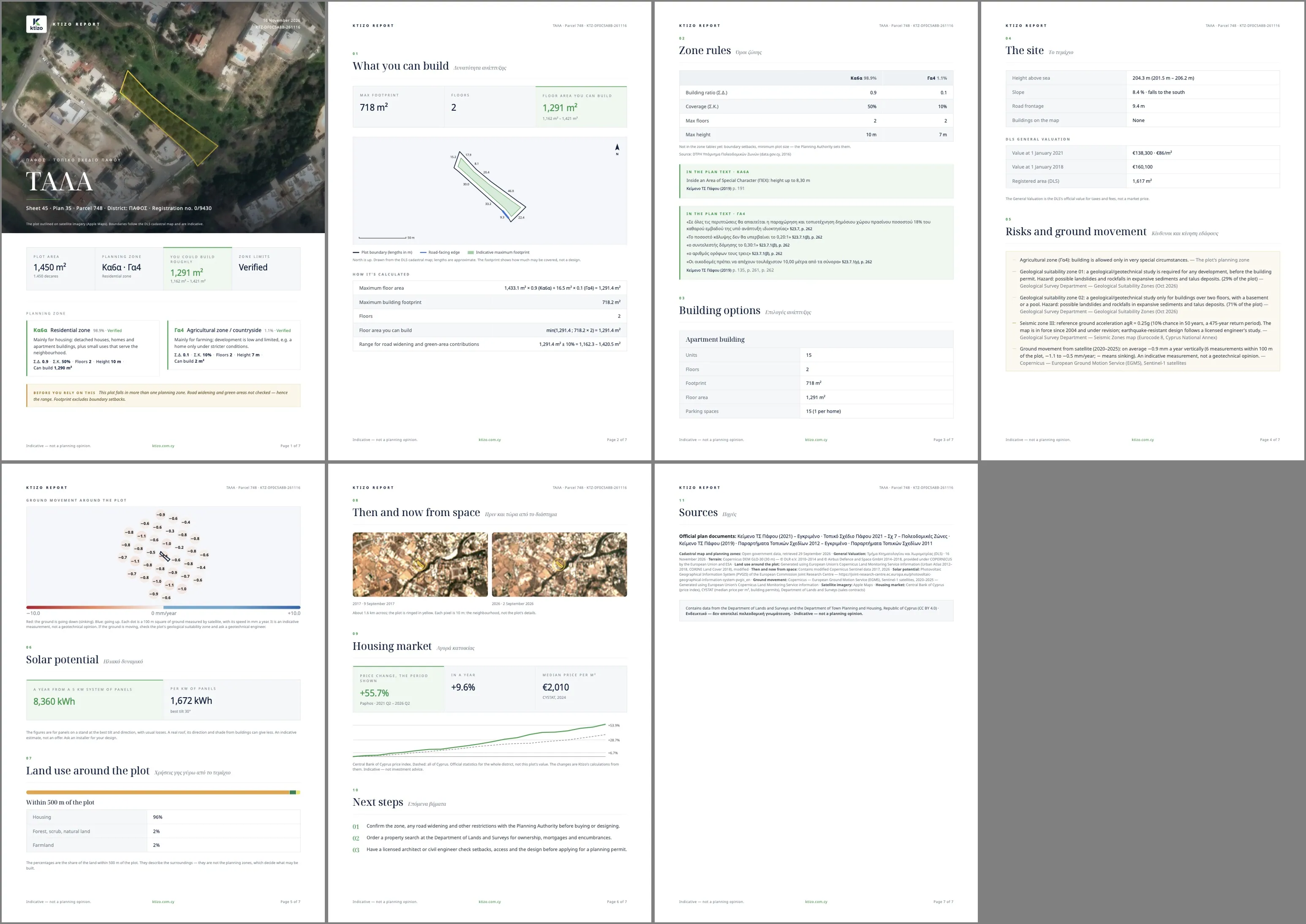
KTIZO REPORT: a redesigned report with every analysis — and every new layer — for your plot.
Ktizo AI
Ask anything about a plot, permits or the planning laws — it quotes the official sources.
Ktizo Marketplace
Plots, homes and land for sale on the map — or sell yours free.
iPhone app · launching soon
The Ktizo iPhone app is with Apple for review. It adds what only a phone can do: scan your title deed with the camera, see the building on your plot in augmented reality, and walk the boundary with GPS. Your Ktizo Account, Library and purchases carry over.
Start free. Unlock one plot, or go Pro for every plot.
Everything for the plot you care about, one purchase.
Every plot, every report, whenever you need it.
For agencies that list and research properties.
Searching plots, zones, building limits, map tools and the marketplace are free. Your first listing is free for 90 days; more listings are €4.99 each (three free with Pro, then €2.00). Pro starts with 7 days free — on the web no card is needed. Prices include VAT. On the web you pay securely with Stripe — card, Apple Pay or Google Pay — and Pro is paid for 30 days or a year at a time, with no automatic renewal. In the iPhone app, Apple charges through the App Store. One Ktizo Account works on both.
A little more clarity before your next step.
Yes, free on every plot: floodplains (20, 100 and 500 years), the Coast Protection Zone, White Zone decrees, geological suitability zones, Natura 2000 and agricultural or protection zones — worst first, with how much of the plot each one touches and its official source. Antiquities and road widening are not checked yet, so always confirm with Town Planning and a licensed professional before you buy or build.
No. Ktizo also helps you explore developed properties, registered buildings and separately titled units. Available details may include areas, construction year, condition, parking and DLS general valuations.
Ktizo works now in any modern browser on a computer, tablet or phone at ktizo.com.cy/app — no download. The iPhone app is coming to the App Store; AR needs a compatible iPhone or iPad with a camera. Your Library, purchases and listings follow your Ktizo Account on every device.
Ktizo uses data from the Cyprus Department of Lands and Surveys (DLS) and official government sources. Source coverage, dates and available details vary by property. Satellite imagery shown in the app is attributed to its provider.
Ktizo provides indicative information. Measurements, boundaries, building details and planning information may differ from current records or actual conditions. 3D and AR models and split previews are visual aids. Confirm details with the relevant authorities and a qualified professional before making a property or building decision.
Exploring is free. A full plot report — with the 3D model, building options and the PDF — is €4.99. Ktizo Pro is €9.99 a month or €89 a year with a 7-day free trial, and the estate agents’ plan is €29 a month. Prices include VAT. On the web you pay with Stripe; in the iPhone app, through the App Store.
Yes. Browsing the Ktizo marketplace is free. To list a property you sign in with a Ktizo Account: your first listing is free for 90 days (renewable); more are €4.99 each, three free with Ktizo Pro (then €2.00 each), and estate agents list without limit on the agents' plan.
Questions about a plot, a purchase or your account? Write to us and we answer within two working days.
In the Ktizo app, open a result sheet and tap “Restore purchases”.
Subscriptions are billed by Apple. Manage or cancel them in your Apple ID settings on your iPhone (Settings → your name → Subscriptions).
In the Ktizo app, go to Account → “Delete account”. You can also write to us and we will help.
Email [email protected] with a link or description of the listing and what is wrong with it. We review every report.
No. Results are indicative and are not a planning opinion, survey or permission to build. Confirm details with DLS, the relevant authorities and a qualified professional.
Support pagePrivacy PolicyTerms of UseMarketplace listing terms
Official sources. Indicative information.
Ktizo uses data from the Cyprus Department of Lands and Surveys (DLS) and official government sources. Measurements, boundaries, building details, valuations and planning information may differ from current records or actual site conditions. 3D and AR views and development estimates are indicative. Ktizo provides information, not building or planning advice, a survey, or permission to build. Confirm details with DLS, the relevant authorities and a qualified professional before relying on them.